
Файл:Hokushin-ron-Map.svg

Size of this PNG preview of this SVG file: 800 × 512 пиксел. Бусад зургын нягтрал: 320 × 205 пиксел | 640 × 409 пиксел | 1,024 × 655 пиксел | 1,280 × 819 пиксел | 2,560 × 1,638 пиксел | 1,038 × 664 пиксел.
Эх файл (SVG файл, 1,038 × 664 пиксэл, файлын хэмжээ: 649 КБ)
| Тайлбар |
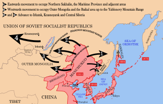
English: Strategic map of "Hoshukin-ron", the Japanese plans for a potential attack on the Soviet Union.
English: A map of the Imperial Powers of the Pacific, 1939-09-01. Dates shown indicate the approximate year that the various powers gain control of their possessions. Japanese control of territory in China was tenuous.
English: A Pacific-centered Mercator projection of the world with countries filled. Created in R using:
library(maps)
|
| Огноо | (UTC) |
| Эх үүсвэр | |
| Зохиогч |
| This is a retouched picture, which means that it has been digitally altered from its original version. Modifications: Redrawn as vector image. The original can be viewed here: Pacific Area - The Imperial Powers 1939 - Map.jpg:
|
Энэ файл нь Creative Commons Attribution-Share Alike 3.0 Unported лицензтэй байна.
- Та чөлөөтэй:
- хуваалцах – бүтээлийг хуулбарлах, түгээх, дамжуулах
- ремикс хийх – ажлыг тохируулах
- Дараах нөхцөлд:
- хамаарал – Та зохих кредитийг өгч, лицензийн холбоосыг өгч, өөрчлөлт оруулсан эсэхийг зааж өгөх ёстой. Та үүнийг ямар ч боломжийн аргаар хийж болно, гэхдээ лиценз олгогч таныг эсвэл таны хэрэглээг зөвшөөрөхгүй.
- адилхан хуваалцах – Хэрэв та материалыг дахин найруулах, хувиргах эсвэл бүтээх юм бол same or compatible license-ийн дагуу өөрийн хувь нэмрийг эх хувьтай нь түгээх ёстой.
Original upload log
This image is a derivative work of the following images:
- File:Hokushin-ron-Map.png licensed with Cc-by-sa-3.0, GFDL
- 2010-08-26T14:40:14Z Begoon 1013x615 (185183 Bytes) remove headline/tweak type
- 2010-01-13T18:41:06Z 36ophiuchi 1013x615 (248571 Bytes) Fixed some minor errors.
- 2010-01-11T23:12:35Z 36ophiuchi 1013x615 (246326 Bytes) {{Information |Description={{en|1=Strategic map of "Hoshukin-ron", the Japanese plans for a potential attack on the Soviet Union.}} |Source=*[[:File:Pacific_Area_-_The_Imperial_Powers_1939_-_Map.svg|]] |Date=2010-01-11 23:11
- File:Pacific_Area_-_The_Imperial_Powers_1939_-_Map.svg licensed with Cc-by-sa-3.0, GFDL
- 2010-08-27T15:13:24Z Splittist 1039x814 (4653684 Bytes) There's no need to create a new file. The map description shows that this map deviates from the one from which it originated: many borders were modified: e.x. East Timor, Mengjiang. It also welcomes changes based on better in
- 2010-08-27T10:11:31Z Kintetsubuffalo 1039x814 (4658296 Bytes) then you are welcome to create your own file, rather than editwarring
- 2010-08-27T06:54:08Z Splittist 1039x814 (4653684 Bytes) Well that map (not the govt, a military academy; and by no means are maps on the area consistent in borders) is wrong. Sheng Shicai, who pledged allegiance to China, controlled Xinjiang in 1939. Marking Xinjiang as separate i
- 2010-08-27T03:36:43Z Kintetsubuffalo 1039x814 (4658296 Bytes) the US government map this is based on shows it as separate
- 2010-08-27T01:26:43Z Splittist 1039x814 (4653684 Bytes) No reason for Xinjiang to have separate borders from China
- 2009-05-31T02:33:19Z Kmusser 1039x814 (4658296 Bytes) add macau, fix marianas, hainan spelling
- 2008-10-30T15:20:49Z Valentim 1039x814 (4703043 Bytes) Reverted to version as of 05:16, 22 September 2008. The international name is "Sea of Japan".
- 2008-09-24T07:42:22Z 쿠도군 1039x814 (4704268 Bytes) Reverted to version as of 07:53, 11 September 2008
- 2008-09-22T05:16:58Z Chris 73 1039x814 (4703043 Bytes) Reverted to version as of 02:54, 21 August 2008
- 2008-09-11T07:53:32Z 쿠도군 1039x814 (4704268 Bytes) new version.
- 2008-08-21T02:54:43Z Emok 1039x814 (4703043 Bytes) {{Information |Description= |Source= |Date= |Author= |Permission= |other_versions= }}
- 2008-08-21T02:44:29Z Emok 1039x814 (4702923 Bytes) {{Information |Description= |Source= |Date= |Author= |Permission= |other_versions= }}
- 2008-08-08T01:16:33Z Emok 1039x814 (4678233 Bytes) {{Information |Description= |Source= |Date= |Author= |Permission= |other_versions= }}
- 2008-08-08T00:07:48Z Emok 1039x814 (4669659 Bytes) {{Information |Description= |Source= |Date= |Author= |Permission= |other_versions= }}
- 2008-08-07T05:03:23Z Emok 1039x814 (4669195 Bytes) {{Information |Description= |Source= |Date= |Author= |Permission= |other_versions= }}
- 2008-08-07T04:28:58Z Emok 1039x814 (4623405 Bytes) {{Information |Description= |Source= |Date= |Author= |Permission= |other_versions= }}
- 2008-08-07T04:02:57Z Emok 1039x814 (4602891 Bytes) {{Information |Description= |Source= |Date= |Author= |Permission= |other_versions= }}
- 2008-08-07T03:24:03Z Emok 1039x814 (4669511 Bytes) {{Information |Description= |Source= |Date= |Author= |Permission= |other_versions= }}
- 2008-08-04T16:59:39Z Emok 1039x814 (6442489 Bytes) {{Information |Description= |Source= |Date= |Author= |Permission= |other_versions= }}
- 2008-08-04T05:38:24Z Emok 1039x814 (6427678 Bytes) {{Information |Description= |Source= |Date= |Author= |Permission= |other_versions= }} [[Category:Imperialism]] [[Category:Oceania]]
- 2008-08-04T05:26:00Z Emok 104x82 (4765313 Bytes) {{Information |Description={{en|1=A map of the Imperial Powers of the Pacific, 1939-09-01. }} |Source=*[[:Image:World2Hires_filled_mercator.svg|]] |Date=2008-08-04 05:22 (UTC) |Author=*derivative work: ~~~ *[[:Image:World2Hir
- File:World2Hires_filled_mercator.svg licensed with Cc-by-sa-3.0, GFDL
- 2008-08-03T06:38:19Z Emok 220x171 (12002488 Bytes) {{Information |Description= |Source= |Date= |Author= |Permission= |other_versions= }} [[Category:Blank SVG maps of the world]]
- 2008-08-03T06:00:29Z Emok 520x519 (3064180 Bytes) {{Information |Description={{en|1=A Pacific-centered Mercator projection of the world with countries filled.}} |Source=Own work by uploader |Author=[[User:Emok|Emok]] |Date=2008-08-01 |Permission= |other_versions= }} {{Image
- File:Pacific_Area_-_The_Imperial_Powers_1939_-_Map.jpg licensed with PD-USGov-Military-Army
Uploaded with derivativeFX
Файлын түүх
Огноо/цаг дээр дарж тухайн үеийнх нь файлын байдлыг харна уу.
| Огноо/Цаг | Жижиг зураг | Хэмжээ | Хэрэглэгч | Тайлбар | |
|---|---|---|---|---|---|
| одоогийн | 03:37, 16 Нэгдүгээр сар 2012 | | 1,038 × 664 (649 КБ) | Quigley | Xinjiang wasn't separate from China |
| 05:40, 29 Наймдугаар сар 2010 |  | 1,038 × 664 (653 КБ) | Begoon | emphasise relevant font weights | |
| 10:04, 28 Наймдугаар сар 2010 |  | 1,038 × 664 (628 КБ) | Begoon | you'd think a mountain range would be big enough not to miss - fixed font for last one... | |
| 10:00, 28 Наймдугаар сар 2010 |  | 1,038 × 664 (626 КБ) | Begoon | font weight for Mountain ranges/Pt Arthur | |
| 09:43, 28 Наймдугаар сар 2010 |  | 1,038 × 664 (619 КБ) | Begoon | {{Information |Description={{en|1=Strategic map of "Hoshukin-ron", the Japanese plans for a potential attack on the Soviet Union.}} {{en|1=A map of the Imperial Powers of the Pacific, 1939-09-01. Dates shown indicate the approximate year that the various |
Холбоос
Дараахь хуудсууд уг файлтай холбогдсон байна:
Файлын хэрэглээ (бүх төсөл)
Дараах бусад вики энэ файлыг ашигладаг:
- azb.wikipedia.org дахь хэрэглээ
- az.wikipedia.org дахь хэрэглээ
- bg.wikipedia.org дахь хэрэглээ
- en.wikipedia.org дахь хэрэглээ
- es.wikipedia.org дахь хэрэглээ
- fa.wikipedia.org дахь хэрэглээ
- fr.wikipedia.org дахь хэрэглээ
- he.wikipedia.org дахь хэрэглээ
- id.wikipedia.org дахь хэрэглээ
- it.wikipedia.org дахь хэрэглээ
- ja.wikipedia.org дахь хэрэглээ
- ko.wikipedia.org дахь хэрэглээ
- ms.wikipedia.org дахь хэрэглээ
- no.wikipedia.org дахь хэрэглээ
- pt.wikipedia.org дахь хэрэглээ
- ru.wikipedia.org дахь хэрэглээ
- uk.wikipedia.org дахь хэрэглээ
- www.wikidata.org дахь хэрэглээ
- zh.wikipedia.org дахь хэрэглээ