
Файл:John-Tallis-1851-Tibet-Mongolia-and-Manchuria-NE.jpg

Эх файл (2,100 × 1,400 пиксел, файлын хэмжээ: 2.34 МБ, MIME төрөл: image/jpeg)
| Тайлбар |
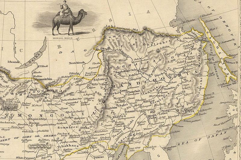
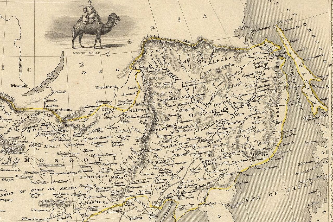
English: The NE section (Manchuria and Mongolia) of the map of the northern and western part of the Chinese Empire - "Thibet, Mongolia, and Mandchouria". The borders are shows as per the 1858 treaty of Aigun. The main Russian center in Transbaikalia is still Nerchinsk, rather than Chita. The outline of Sakhalin is already shown fairly correctly, but the body of water separating it from the mainland is still labeled "Gulf of Tartary" (rather than '"Strait). |
| Огноо | (UTC) |
| Эх үүсвэр | |
| Зохиогч |
|
| Other versions |
 |
| This is a retouched picture, which means that it has been digitally altered from its original version. Modifications: NE section. The original can be viewed here: John-Tallis-1851-Tibet-Mongolia-and-Manchuria-33621.jpg:
|
|
This work is in the public domain in its country of origin and other countries and areas where the copyright term is the author's life plus 70 years or fewer.
| |
| This file has been identified as being free of known restrictions under copyright law, including all related and neighboring rights. | |
Original upload log
This image is a derivative work of the following images:
- File:John-Tallis-1851-Tibet-Mongolia-and-Manchuria-33621.jpg licensed with PD-old
- 2009-12-07T02:26:08Z Vmenkov 4700x3750 (4267392 Bytes) better resolution, as available from http://www.davidrumsey.com/luna/servlet/detail/RUMSEY~8~1~821~60126:Thibet,-Mongolia,-and-Mandchouria--
- 2009-12-07T01:38:06Z Vmenkov 1289x989 (395245 Bytes) {{Information |Description={{en|1=Map of the northern and western part of the Chinese Empire - "Thibet, Mongolia, and Mandchouria".
Uploaded with derivativeFX
Файлын түүх
Огноо/цаг дээр дарж тухайн үеийнх нь файлын байдлыг харна уу.
| Огноо/Цаг | Жижиг зураг | Хэмжээ | Хэрэглэгч | Тайлбар | |
|---|---|---|---|---|---|
| одоогийн | 03:10, 7 Арванхоёрдугаар сар 2009 | | 2,100 × 1,400 (2.34 МБ) | Vmenkov | {{Information |Description={{en|1=The NE section (Manchuria and Mongolia) of the map of the northern and western part of the Chinese Empire - "Thibet, Mongolia, and Mandchouria". The borders are shows as per the 1858 treaty of Aigun. The main Russian cent |
Холбоос
Дараахь хуудсууд уг файлтай холбогдсон байна:
Файлын хэрэглээ (бүх төсөл)
Дараах бусад вики энэ файлыг ашигладаг:
- ar.wikipedia.org дахь хэрэглээ
- bn.wikipedia.org дахь хэрэглээ
- ca.wikipedia.org дахь хэрэглээ
- cs.wikipedia.org дахь хэрэглээ
- cv.wikipedia.org дахь хэрэглээ
- da.wikipedia.org дахь хэрэглээ
- de.wikipedia.org дахь хэрэглээ
- en.wikipedia.org дахь хэрэглээ
- en.wiktionary.org дахь хэрэглээ
- eo.wikipedia.org дахь хэрэглээ
- es.wikipedia.org дахь хэрэглээ
- fi.wikipedia.org дахь хэрэглээ
- fr.wikipedia.org дахь хэрэглээ
- hy.wikipedia.org дахь хэрэглээ
- id.wikipedia.org дахь хэрэглээ
- it.wikipedia.org дахь хэрэглээ
- ja.wikipedia.org дахь хэрэглээ
- ka.wikipedia.org дахь хэрэглээ
- kk.wikipedia.org дахь хэрэглээ
- ko.wikipedia.org дахь хэрэглээ
- la.wikipedia.org дахь хэрэглээ
- lt.wikipedia.org дахь хэрэглээ
- no.wikipedia.org дахь хэрэглээ
- pl.wikipedia.org дахь хэрэглээ
- pl.wiktionary.org дахь хэрэглээ
- pt.wikipedia.org дахь хэрэглээ
Энэ файлын дэлхийн хэрэглээг харах.