
Файл:Aerial view of the Central Intelligence Agency headquarters, Langley, Virginia - Corrected and Cropped.jpg
Үзлэгийн хэмжээ : 800 × 356 пиксел Бусад зургын нягтрал: 320 × 142 пиксел | 640 × 284 пиксел | 1,024 × 455 пиксел | 1,280 × 569 пиксел | 2,560 × 1,138 пиксел | 5,523 × 2,455 пиксел.
Эх файл (5,523 × 2,455 пиксел, файлын хэмжээ: 7.57 МБ, MIME төрөл: image/jpeg)
Товч агуулга
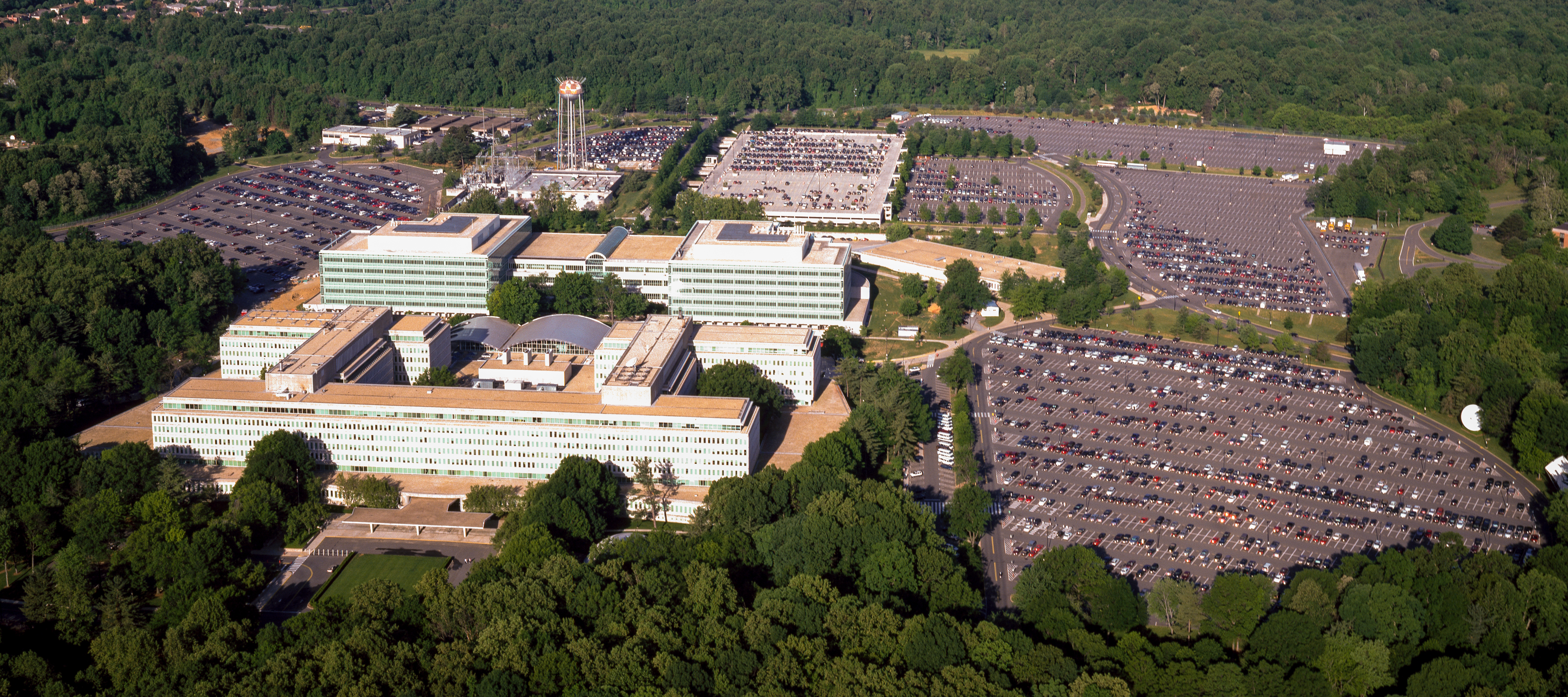
| Aerial view of the Central Intelligence Agency headquarters, Langley, Virginia
( |
|||||||||||||||||||||||||||
|---|---|---|---|---|---|---|---|---|---|---|---|---|---|---|---|---|---|---|---|---|---|---|---|---|---|---|---|
| Зохиогч |
|
||||||||||||||||||||||||||
| Title |
Aerial view of the Central Intelligence Agency headquarters, Langley, Virginia |
||||||||||||||||||||||||||
| Depicted place | Central Intelligence Agency headquarters | ||||||||||||||||||||||||||
| Огноо | ᠑,᠙᠘᠐.᠐ - ᠒,᠐᠐᠖.᠐ | ||||||||||||||||||||||||||
| Medium | 1 transparency : color | ||||||||||||||||||||||||||
| Dimensions | 4 x 5 in. or smaller. | ||||||||||||||||||||||||||
| Collection |
|
||||||||||||||||||||||||||
| Current location |
Prints and Photographs Division http://hdl.loc.gov/loc.pnp/pp.print |
||||||||||||||||||||||||||
| Notes |
|
||||||||||||||||||||||||||
| Эх үүсвэр |
|
||||||||||||||||||||||||||
| Зөвшөөрөл (Энэ файлыг дахин ашиглах) |
Rights Advisory: No known restrictions on publication. | ||||||||||||||||||||||||||
| Other versions |
|
||||||||||||||||||||||||||


| | View this and other nearby images on: OpenStreetMap |
Лиценз
| This work is from the Carol M. Highsmith Archive collection at the Library of Congress. According to the library, there are no known copyright restrictions on the use of this work. Carol M. Highsmith has stipulated that her photographs are in the public domain. Photographs of sculpture or other works of art may be restricted by the copyright of the artist. |
 |
Файлын түүх
Огноо/цаг дээр дарж тухайн үеийнх нь файлын байдлыг харна уу.
| Огноо/Цаг | Жижиг зураг | Хэмжээ | Хэрэглэгч | Тайлбар | |
|---|---|---|---|---|---|
| одоогийн | 16:17, 22 Дөрөвдүгээр сар 2017 | | 5,523 × 2,455 (7.57 МБ) | Falcorian | User created page with UploadWizard |
Холбоос
Дараахь хуудсууд уг файлтай холбогдсон байна:
Файлын хэрэглээ (бүх төсөл)
Дараах бусад вики энэ файлыг ашигладаг:
- ar.wikipedia.org дахь хэрэглээ
- arz.wikipedia.org дахь хэрэглээ
- ast.wikipedia.org дахь хэрэглээ
- azb.wikipedia.org дахь хэрэглээ
- az.wikipedia.org дахь хэрэглээ
- br.wikipedia.org дахь хэрэглээ
- ca.wikipedia.org дахь хэрэглээ
- ce.wikipedia.org дахь хэрэглээ
- cs.wikipedia.org дахь хэрэглээ
- cy.wikipedia.org дахь хэрэглээ
- da.wikipedia.org дахь хэрэглээ
- de.wikipedia.org дахь хэрэглээ
- en.wikipedia.org дахь хэрэглээ
- eo.wikipedia.org дахь хэрэглээ
- eo.wikiquote.org дахь хэрэглээ
- es.wikipedia.org дахь хэрэглээ
- fi.wikipedia.org дахь хэрэглээ
- fr.wikipedia.org дахь хэрэглээ
- fr.wikinews.org дахь хэрэглээ
- ga.wikipedia.org дахь хэрэглээ
- ha.wikipedia.org дахь хэрэглээ
- he.wikipedia.org дахь хэрэглээ
- hu.wikipedia.org дахь хэрэглээ
- id.wikipedia.org дахь хэрэглээ
- it.wikipedia.org дахь хэрэглээ
- ja.wikipedia.org дахь хэрэглээ
- ko.wikipedia.org дахь хэрэглээ
- ky.wikipedia.org дахь хэрэглээ
- lv.wikipedia.org дахь хэрэглээ
- ne.wikipedia.org дахь хэрэглээ
- nn.wikipedia.org дахь хэрэглээ
- no.wikipedia.org дахь хэрэглээ
- ro.wikipedia.org дахь хэрэглээ
- ru.wikipedia.org дахь хэрэглээ
- ru.wikinews.org дахь хэрэглээ
- sk.wikipedia.org дахь хэрэглээ
- sl.wikipedia.org дахь хэрэглээ
Энэ файлын дэлхийн хэрэглээг харах.