
Файл:Cities in China.png
Үзлэгийн хэмжээ : 759 × 600 пиксел Бусад зургын нягтрал: 304 × 240 пиксел | 607 × 480 пиксел | 972 × 768 пиксел | 1,280 × 1,012 пиксел | 2,560 × 2,023 пиксел | 6,246 × 4,937 пиксел.
Эх файл (6,246 × 4,937 пиксел, файлын хэмжээ: 895 КБ, MIME төрөл: image/png)

|
This image is expected to always be the most recent one. Feel free to update it when needed.
|

|
This file may be updated to reflect new information. If you wish to use a specific version of the file without new updates being mirrored, please upload the required version as a separate file. |
Товч агуулга
| Тайлбар |
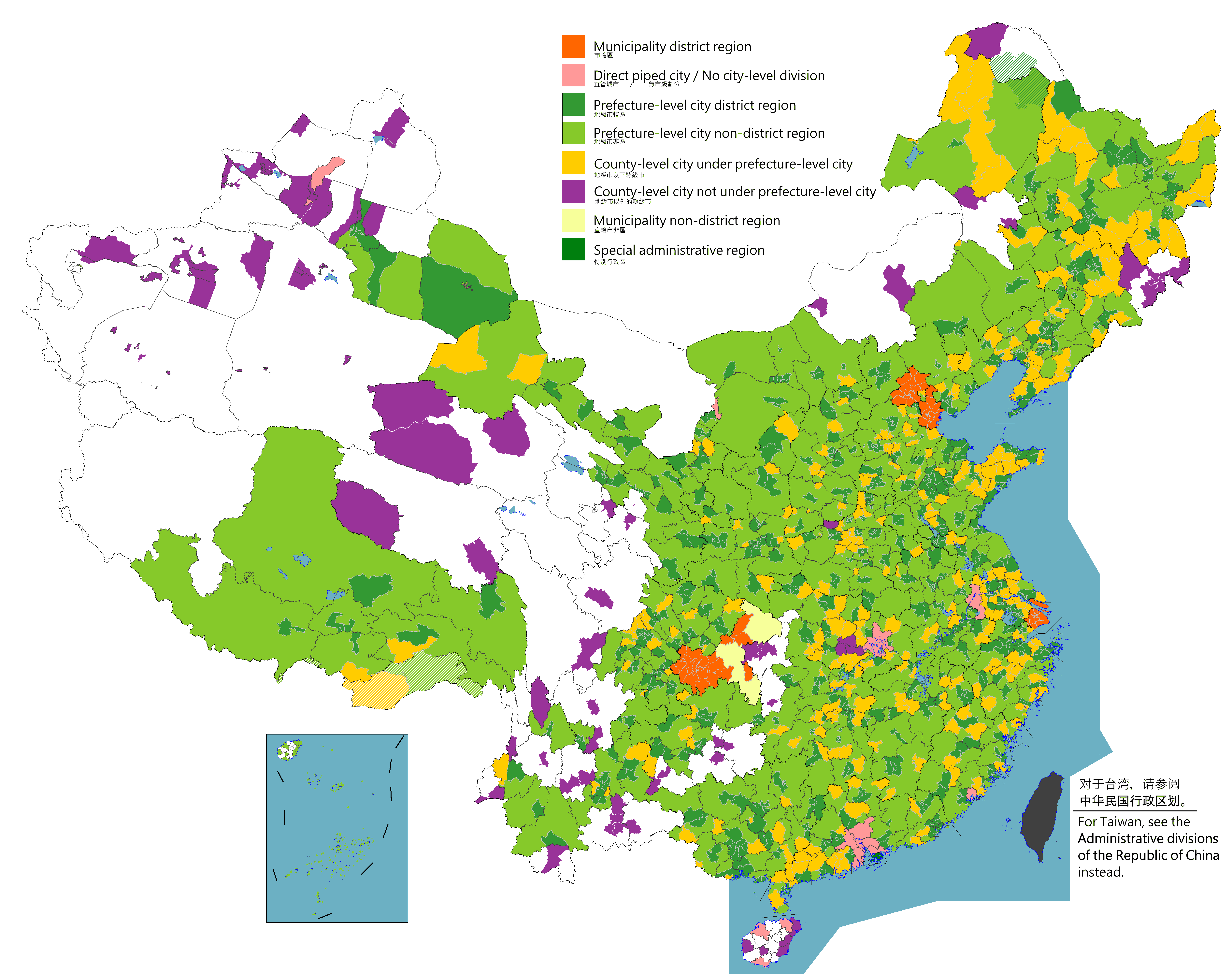
English: Map of China's types of cities.
日本語: 中国の都市の種類の地図。
Русский: Карта типов городов Китая.
Монгол: Хятадын төрлийн хотуудын газрын зураг.
中文(简体):中国城市类型图。(包含未實際控制之疆域)
中文(繁體):中國城市類型圖。 (包含未實際控制之疆域) |
||
| Огноо |
|
||
| Эх үүсвэр |
Legend: Municipality district region
Direct piped city / No city-level division
Prefecture-level city district region
Prefecture-level city non-district region
County-level city under prefecture-level city
County-level city not prefecture-level city
Municipality non-district region
Special administrative region
Source appearances:
[]
|
||
| Зохиогч |
|
||
| Зөвшөөрөл (Энэ файлыг дахин ашиглах) |
Map of China, types of cities: I, the copyright holder of this work, hereby publish it under the following license:
|
.png)
.png)
Лиценз
I, the copyright holder of this work, hereby publish it under the following license:
This file is licensed under the Creative Commons Attribution-Share Alike 4.0 International license.
- Та чөлөөтэй:
- хуваалцах – бүтээлийг хуулбарлах, түгээх, дамжуулах
- ремикс хийх – ажлыг тохируулах
- Дараах нөхцөлд:
- хамаарал – Та зохих кредитийг өгч, лицензийн холбоосыг өгч, өөрчлөлт оруулсан эсэхийг зааж өгөх ёстой. Та үүнийг ямар ч боломжийн аргаар хийж болно, гэхдээ лиценз олгогч таныг эсвэл таны хэрэглээг зөвшөөрөхгүй.
- адилхан хуваалцах – Хэрэв та материалыг дахин найруулах, хувиргах эсвэл бүтээх юм бол same or compatible license-ийн дагуу өөрийн хувь нэмрийг эх хувьтай нь түгээх ёстой.

|
This locator map image could be re-created using vector graphics as an SVG file. This has several advantages; see Commons:Media for cleanup for more information. If an SVG form of this image is available, please upload it and afterwards replace this template with
{{vector version available|new image name}}.
It is recommended to name the SVG file “Cities in China.svg”—then the template Vector version available (or Vva) does not need the new image name parameter. |
|
|
This map image could be re-created using vector graphics as an SVG file. This has several advantages; see Commons:Media for cleanup for more information. If an SVG form of this image is available, please upload it and afterwards replace this template with
{{vector version available|new image name}}.
It is recommended to name the SVG file “Cities in China.svg”—then the template Vector version available (or Vva) does not need the new image name parameter. |
| Annotations | This image is annotated: View the annotations at Commons |
Файлын түүх
Огноо/цаг дээр дарж тухайн үеийнх нь файлын байдлыг харна уу.
| Огноо/Цаг | Жижиг зураг | Хэмжээ | Хэрэглэгч | Тайлбар | |
|---|---|---|---|---|---|
| одоогийн | 10:09, 2 Наймдугаар сар 2023 | | 6,246 × 4,937 (895 КБ) | Maanshen | |
| 09:59, 2 Наймдугаар сар 2023 |  | 6,246 × 4,937 (897 КБ) | Maanshen | ||
| 09:51, 2 Наймдугаар сар 2023 |  | 6,246 × 4,937 (893 КБ) | Maanshen | ||
| 08:59, 1 Наймдугаар сар 2023 |  | 6,246 × 4,937 (891 КБ) | Maanshen | ||
| 23:06, 2 Наймдугаар сар 2022 |  | 6,246 × 4,937 (901 КБ) | Maanshen | Update disputed/claimed borders, white with stroke is not claimed and filled in color is claimed | |
| 00:08, 20 Дөрөвдүгээр сар 2022 |  | 6,246 × 4,937 (893 КБ) | Maanshen | Fix borders between Ili's Kuytun, Huyanghe, and Karamay | |
| 01:45, 31 Гуравдугаар сар 2022 |  | 6,246 × 4,937 (893 КБ) | Maanshen | Fix some colors | |
| 00:59, 29 Гуравдугаар сар 2022 |  | 6,246 × 4,937 (893 КБ) | Maanshen | Fix colors in Shanxi with Fenyang and Xiaoyi | |
| 01:00, 17 Гуравдугаар сар 2022 |  | 6,246 × 4,937 (893 КБ) | Maanshen | Fix Dongtai as a county-level city | |
| 03:51, 1 Гуравдугаар сар 2022 |  | 6,246 × 4,937 (893 КБ) | Maanshen | Update Shanghai land reclamation and cpunty border changes as of 2022 |
Холбоос
Дараахь хуудсууд уг файлтай холбогдсон байна:
Файлын хэрэглээ (бүх төсөл)
Дараах бусад вики энэ файлыг ашигладаг:
- en.wikipedia.org дахь хэрэглээ
- fi.wikipedia.org дахь хэрэглээ
- id.wikipedia.org дахь хэрэглээ
- ilo.wikipedia.org дахь хэрэглээ
- ko.wikipedia.org дахь хэрэглээ
- ku.wikipedia.org дахь хэрэглээ
- mk.wikipedia.org дахь хэрэглээ
- th.wikipedia.org дахь хэрэглээ
- tr.wikipedia.org дахь хэрэглээ
- uz.wikipedia.org дахь хэрэглээ
- zh.wikipedia.org дахь хэрэглээ