
Файл:Italy 1494 AD.png

Үзлэгийн хэмжээ : 419 × 600 пиксел Бусад зургын нягтрал: 168 × 240 пиксел | 335 × 480 пиксел | 536 × 768 пиксел | 1,261 × 1,805 пиксел.
Эх файл (1,261 × 1,805 пиксел, файлын хэмжээ: 144 КБ, MIME төрөл: image/png)


|
File:Italy 1494 AD-it.svg is a vector version of this file. It should be used in place of this PNG file when not inferior.
File:Italy 1494 AD.png → File:Italy 1494 AD-it.svg
For more information, see Help:SVG. |
 |
Товч агуулга
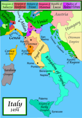
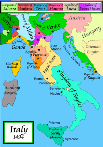
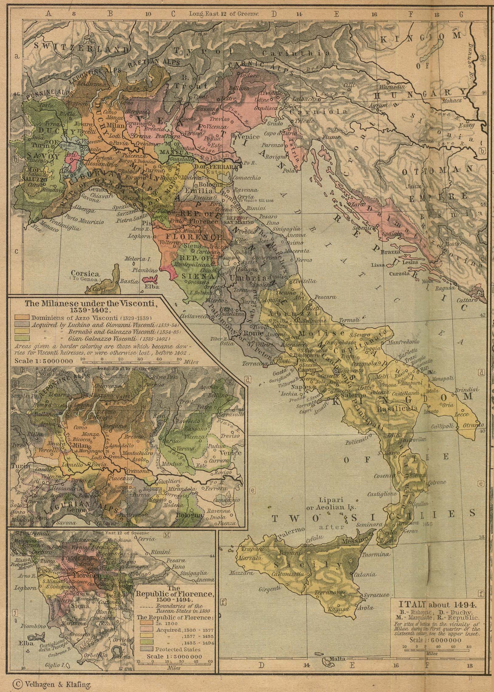
Political map of Italy in early 1494, before the invasion of Italy by Charles VIII of France, created by MapMaster.
Part of a series of maps on the history of Italy:
-
 1000 AD
 -
 1084 AD
 -
 1796 AD
 -
 1810 AD


Versions
[]
PNG:
-
 араб
араб -
 англи
англи -
 грек
грек


SVG:
-
 франц
франц -
 итали
итали -
 мажар
мажар


References
- Bjorklund, Oddvar; Holmboe, Haakon; Rohr, Anders (1970) Historical Atlas of the World, Barnes & Noble, NY, SBN: 389-00253-4.
- Matthew, Donald, (1983), Atlas of Medieval Europe, Checkmark Books, New York.
- Online maps, including this 1882 map from Shepherd (the University of Texas)
- this one from A B Longman, textbook publisher.
Лиценз
I, the copyright holder of this work, hereby publish it under the following licenses:

|
Энэхүү баримт бичгийг GNU Free Documentation License, Хувилбарын нөхцлийн дагуу хуулах, түгээх болон/эсвэл өөрчлөх зөвшөөрөл олгосон. 1.2 эсвэл Чөлөөт програм хангамжийн сангаас нийтэлсэн дараагийн хувилбар; Инвариант хэсэггүй, нүүрэн талын текстгүй, арын хавтастай текстгүй. Лицензийн хуулбарыг GNU Free Documentation License гэсэн хэсэгт оруулсан болно. |
| Энэ файл нь Creative Commons Attribution-Share Alike 3.0 Unported лицензтэй байна. | ||
| ||
| This licensing tag was added to this file as part of the GFDL licensing update. |
Та өөрийн хүссэн лицензээ сонгож болно.
derivative works
Derivative works of this file: Italy 1494 AD-ar.png
Файлын түүх
Огноо/цаг дээр дарж тухайн үеийнх нь файлын байдлыг харна уу.
| Огноо/Цаг | Жижиг зураг | Хэмжээ | Хэрэглэгч | Тайлбар | |
|---|---|---|---|---|---|
| одоогийн | 01:15, 21 Дөрөвдүгээр сар 2009 | | 1,261 × 1,805 (144 КБ) | Capmo | palette reduction to 256 colours |
| 22:04, 14 Дөрөвдүгээр сар 2007 |  | 1,261 × 1,805 (539 КБ) | MapMaster | Minor modifications | |
| 16:07, 27 Хоёрдугаар сар 2007 |  | 1,167 × 1,642 (471 КБ) | MapMaster | Modification suggested by User:Paolo da Reggio | |
| 23:52, 8 Нэгдүгээр сар 2007 |  | 1,135 × 1,625 (472 КБ) | MapMaster | Political map of Italy in early 1494, before the invasion of Italy by Charles VIII of France, created by MapMaster. |
Холбоос
Дараахь хуудсууд уг файлтай холбогдсон байна:
Файлын хэрэглээ (бүх төсөл)
Дараах бусад вики энэ файлыг ашигладаг:
- af.wikipedia.org дахь хэрэглээ
- azb.wikipedia.org дахь хэрэглээ
- az.wikipedia.org дахь хэрэглээ
- bg.wikipedia.org дахь хэрэглээ
- br.wikipedia.org дахь хэрэглээ
- bxr.wikipedia.org дахь хэрэглээ
- ca.wikipedia.org дахь хэрэглээ
- cs.wikipedia.org дахь хэрэглээ
- de.wikipedia.org дахь хэрэглээ
- el.wikipedia.org дахь хэрэглээ
- en.wikipedia.org дахь хэрэглээ
- Pope Alexander VI
- Renaissance
- Italian Wars
- Gonzalo Fernández de Córdoba
- Duke of Ferrara and of Modena
- Italian War of 1494–1495
- List of rulers of Montferrat
- User:MapMaster
- Military history of Italy
- User:Juanpdp/Italy
- User:Bolonium/Renaissance
- Marquisate of Incisa
- Timeline of Niccolò Machiavelli
- Italic League
- eo.wikipedia.org дахь хэрэглээ
- es.wikipedia.org дахь хэрэглээ
- et.wikipedia.org дахь хэрэглээ
- fa.wikipedia.org дахь хэрэглээ
Энэ файлын дэлхийн хэрэглээг харах.