
Файл:Kandahar districts.png

Үзлэгийн хэмжээ : 786 × 600 пиксел Бусад зургын нягтрал: 315 × 240 пиксел | 629 × 480 пиксел | 1,000 × 763 пиксел.
Эх файл (1,000 × 763 пиксел, файлын хэмжээ: 30 КБ, MIME төрөл: image/png)

|
This locator map image could be re-created using vector graphics as an SVG file. This has several advantages; see Commons:Media for cleanup for more information. If an SVG form of this image is available, please upload it and afterwards replace this template with
{{vector version available|new image name}}.
It is recommended to name the SVG file “Kandahar districts.svg”—then the template Vector version available (or Vva) does not need the new image name parameter. |
Товч агуулга

|
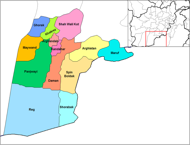
This file requires updating because: Does not include Miyanishin District or Zhari District. Miyanishin was created from the Northern part of Shah Wali Kot. Zhari was created from parts of Maywand and Panjwai In doing so, you could add a timestamp to the file.
|
English: Map of the districts of Kandahar province of Afghanistan. Created by Rarelibra 19:26, 29 March 2007 (UTC) for public domain use, using MapInfo Professional v8.5 and various mapping resources.
Лиценз
| I, the copyright holder of this work, release this work into the public domain. This applies worldwide. In some countries this may not be legally possible; if so: I grant anyone the right to use this work for any purpose, without any conditions, unless such conditions are required by law. |
Файлын түүх
Огноо/цаг дээр дарж тухайн үеийнх нь файлын байдлыг харна уу.
| Огноо/Цаг | Жижиг зураг | Хэмжээ | Хэрэглэгч | Тайлбар | |
|---|---|---|---|---|---|
| одоогийн | 14:47, 15 Хоёрдугаар сар 2024 | | 1,000 × 763 (30 КБ) | User-duck | Cropped 5 % horizontally, 6 % vertically using CropTool with lossless mode. |
| 19:26, 29 Гуравдугаар сар 2007 |  | 1,056 × 816 (30 КБ) | Rarelibra | Map of the districts of Kandahar province of Afghanistan. Created by ~~~~ for public domain use, using MapInfo Professional v8.5 and various mapping resources. |
Холбоос
Дараахь хуудсууд уг файлтай холбогдсон байна:
Файлын хэрэглээ (бүх төсөл)
Дараах бусад вики энэ файлыг ашигладаг:
- ar.wikipedia.org дахь хэрэглээ
- bn.wikipedia.org дахь хэрэглээ
- ca.wikipedia.org дахь хэрэглээ
- da.wikipedia.org дахь хэрэглээ
- de.wikipedia.org дахь хэрэглээ
- en.wikipedia.org дахь хэрэглээ
- en.wikinews.org дахь хэрэглээ
- es.wikipedia.org дахь хэрэглээ
- et.wikipedia.org дахь хэрэглээ
- fr.wikipedia.org дахь хэрэглээ
- he.wikipedia.org дахь хэрэглээ
- incubator.wikimedia.org дахь хэрэглээ
- it.wikipedia.org дахь хэрэглээ
- ja.wikipedia.org дахь хэрэглээ
- lt.wikipedia.org дахь хэрэглээ
- ms.wikipedia.org дахь хэрэглээ
- nl.wikipedia.org дахь хэрэглээ
- no.wikipedia.org дахь хэрэглээ
Энэ файлын дэлхийн хэрэглээг харах.