
Файл:Kansai closeup.jpg
Үүнээс илүү чанартай хувилбар байхгүй байна.
Kansai_closeup.jpg (800 × 600 пиксел, файлын хэмжээ: 66 КБ, MIME төрөл: image/jpeg)
Товч агуулга
| Тайлбар |
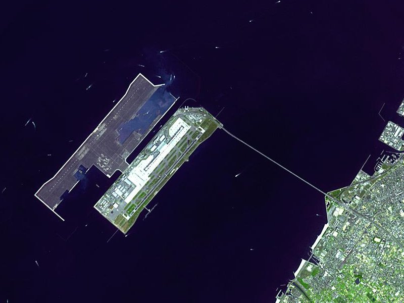
Satellite image of Kansai International Airport in Osaka Bay in Japan. This is a closeup - for an overview image showing the airport on its artificial island in the bay, see Image:Wfm kansai overview.jpg |
| Огноо | |
| Эх үүсвэр |
Taken from an uncopyrighted image NASA Earth Observatory |
| Зохиогч | NASA Earth Observatory |
| Зөвшөөрөл (Энэ файлыг дахин ашиглах) |
"The purpose of NASA's Earth Observatory is to provide a freely-accessible publication on the Internet where the public can obtain new satellite imagery and scientific information about our home planet. The focus is on Earth's climate and environmental change. In particular, we hope our site is useful to public media and educators. Any and all materials published on the Earth Observatory are freely available for re-publication or re-use, except where copyright is indicated. We ask that NASA's Earth Observatory be given credit for its original materials." |
| Other versions |

| Object location | | View this and other nearby images on: OpenStreetMap |
|---|
Лиценз
| This file is in the public domain in the United States because it was solely created by NASA. NASA copyright policy states that "NASA material is not protected by copyright unless noted". (See Template:PD-USGov, NASA copyright policy page or JPL Image Use Policy.) | ||
 |
Warnings:
|
en.Wikipedia upload log
The en.Wikipedia description page is/was here. All following user names refer to en.Wikipedia.
- 2004-04-05 19:30 Finlay McWalter 800×600 (66 KB) (nasa image of kansai airport)
Файлын түүх
Огноо/цаг дээр дарж тухайн үеийнх нь файлын байдлыг харна уу.
| Огноо/Цаг | Жижиг зураг | Хэмжээ | Хэрэглэгч | Тайлбар | |
|---|---|---|---|---|---|
| одоогийн | 03:46, 13 Арванхоёрдугаар сар 2005 | | 800 × 600 (66 КБ) | Sam916~commonswiki | Satellite image of Kansai International Airport in Osaka Bay in Japan. This is a closeup - for an overview image showing the airport on its artificial island in the bay, see Image:Wfm kansai overview.jpg Taken from an uncopyrighted imag |
Холбоос
Дараахь хуудсууд уг файлтай холбогдсон байна:
Файлын хэрэглээ (бүх төсөл)
Дараах бусад вики энэ файлыг ашигладаг:
- ar.wikipedia.org дахь хэрэглээ
- ast.wikipedia.org дахь хэрэглээ
- bbc.wikipedia.org дахь хэрэглээ
- bg.wikipedia.org дахь хэрэглээ
- bh.wikipedia.org дахь хэрэглээ
- bn.wikipedia.org дахь хэрэглээ
- de.wikipedia.org дахь хэрэглээ
- el.wikipedia.org дахь хэрэглээ
- en.wikipedia.org дахь хэрэглээ
- en.wikibooks.org дахь хэрэглээ
- es.wikipedia.org дахь хэрэглээ
- eu.wikipedia.org дахь хэрэглээ
- fa.wikipedia.org дахь хэрэглээ
- fi.wikipedia.org дахь хэрэглээ
- he.wikipedia.org дахь хэрэглээ
- hu.wikipedia.org дахь хэрэглээ
- id.wikipedia.org дахь хэрэглээ
- io.wikipedia.org дахь хэрэглээ
- it.wikipedia.org дахь хэрэглээ
- it.wikivoyage.org дахь хэрэглээ
- ja.wikipedia.org дахь хэрэглээ
- ko.wikipedia.org дахь хэрэглээ
- lfn.wikipedia.org дахь хэрэглээ
- ml.wikipedia.org дахь хэрэглээ
- ms.wikipedia.org дахь хэрэглээ
- nl.wikipedia.org дахь хэрэглээ
- pt.wikipedia.org дахь хэрэглээ
- ro.wikipedia.org дахь хэрэглээ
- simple.wikipedia.org дахь хэрэглээ
- sl.wikipedia.org дахь хэрэглээ
- sr.wikipedia.org дахь хэрэглээ
- sv.wikipedia.org дахь хэрэглээ
- ta.wikipedia.org дахь хэрэглээ
- uk.wikipedia.org дахь хэрэглээ
- vi.wikipedia.org дахь хэрэглээ
- www.wikidata.org дахь хэрэглээ
- zh-yue.wikipedia.org дахь хэрэглээ
- zh.wikipedia.org дахь хэрэглээ
Энэ файлын дэлхийн хэрэглээг харах.