
Файл:Map of Lydia ancient times-ru.svg

Size of this PNG preview of this SVG file: 400 × 277 пиксел. Бусад зургын нягтрал: 320 × 222 пиксел | 640 × 443 пиксел | 1,024 × 709 пиксел | 1,280 × 886 пиксел | 2,560 × 1,773 пиксел.
Эх файл (SVG файл, 400 × 277 пиксэл, файлын хэмжээ: 47 КБ)
| Тайлбар | |
| Огноо | (UTC) |
| Эх үүсвэр | |
| Зохиогч |
|
| Other versions |
[]
|


| This is a retouched picture, which means that it has been digitally altered from its original version. Modifications: to svg and russification. The original can be viewed here: Map of Lydia ancient times.jpg:
|
I, the copyright holder of this work, hereby publish it under the following license:

|
Энэхүү баримт бичгийг GNU Free Documentation License, Хувилбарын нөхцлийн дагуу хуулах, түгээх болон/эсвэл өөрчлөх зөвшөөрөл олгосон. 1.2 эсвэл Чөлөөт програм хангамжийн сангаас нийтэлсэн дараагийн хувилбар; Инвариант хэсэггүй, нүүрэн талын текстгүй, арын хавтастай текстгүй. Лицензийн хуулбарыг GNU Free Documentation License гэсэн хэсэгт оруулсан болно. |
| Энэ файл нь Creative Commons Attribution-Share Alike 3.0 Unported лицензтэй байна. | ||
| ||
| This licensing tag was added to this file as part of the GFDL licensing update. |
Original upload log
This image is a derivative work of the following images:
- File:Map_of_Lydia_ancient_times.jpg licensed with GFDL
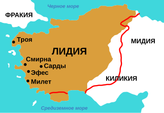
- 2005-10-26T06:21:40Z Roke 400x277 (44624 Bytes) made by me, from info from maps here [http://i-cias.com/e.o/lydia.htm] and here [http://www.ancientanatolia.com/map07.htm]. Edge of the brown area is the border of Lydia at the middle of the 6th century BC. The red line is th
Uploaded with derivativeFX
Файлын түүх
Огноо/цаг дээр дарж тухайн үеийнх нь файлын байдлыг харна уу.
| Огноо/Цаг | Жижиг зураг | Хэмжээ | Хэрэглэгч | Тайлбар | |
|---|---|---|---|---|---|
| одоогийн | 16:16, 17 Тавдугаар сар 2009 | | 400 × 277 (47 КБ) | Nekto | white background |
| 16:08, 17 Тавдугаар сар 2009 |  | 400 × 277 (47 КБ) | Nekto | {{Information |Description=made by me, from info from maps here [http://i-cias.com/e.o/lydia.htm] and here [http://www.ancientanatolia.com/map07.htm]. Edge of the brown area is the border of Lydia at the middle of the 6th century BC. The red line is the d |
Холбоос
Дараахь хуудсууд уг файлтай холбогдсон байна:
Файлын хэрэглээ (бүх төсөл)
Дараах бусад вики энэ файлыг ашигладаг:
- az.wikipedia.org дахь хэрэглээ
- ba.wikipedia.org дахь хэрэглээ
- bg.wikipedia.org дахь хэрэглээ
- cv.wikipedia.org дахь хэрэглээ
- ru.wikipedia.org дахь хэрэглээ
- tt.wikipedia.org дахь хэрэглээ
- uk.wikipedia.org дахь хэрэглээ