
Файл:Prince Edward Island map 1775.jpg
Эх файл (1,216 × 639 пиксел, файлын хэмжээ: 167 КБ, MIME төрөл: image/jpeg)
Товч агуулга
| Тайлбар |
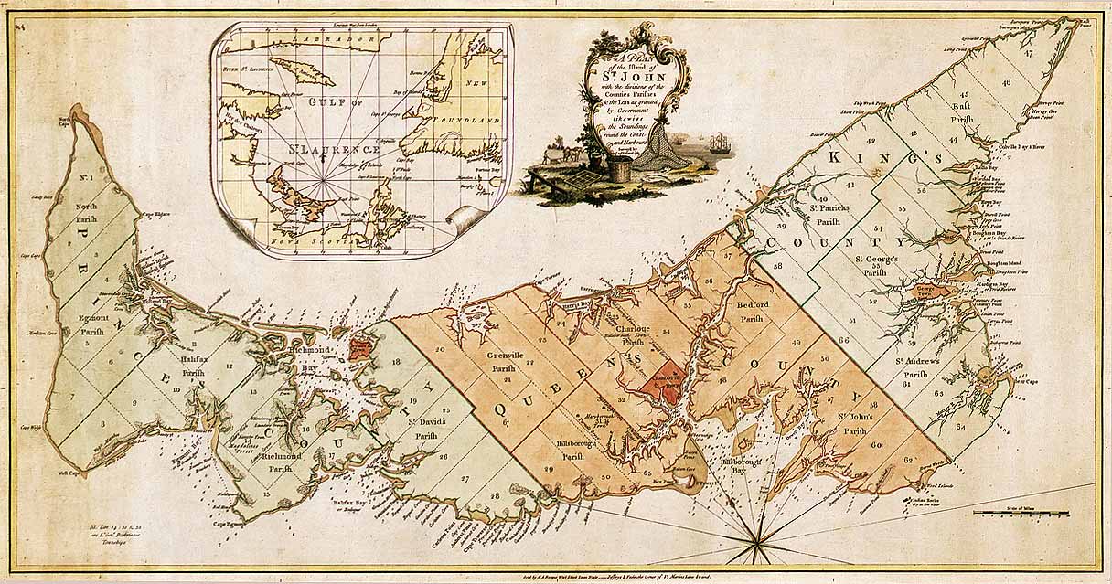
English: Map of Prince Edward Island in 1775. Titled: "A plan of the island of St. John with the divisions of the counties parishes & the lots as granted by government likewise the soundings round the coast and harbours. Surveyed by Capt. Holland. 1775." The island was the first of the new English colonies for which a general survey was conducted. Samuel Holland was in charge of the survey. Known as Île Saint-Jean at the time of the French, and later Saint John Island, it did not take its present name until 1799. This very detailed plan shows the projected counties, parishes, townships and lots on the island following the expulsion of the Acadians in 1758. Samuel Holland, surveyor general of the province of Quebec, surveyed the island in the fall of 1764. He identified the location of the capital and named it Charlottetown. The counties and townships are listed with their sizes in acres. Inset map of the Gulf of St. Lawrence. Decorative cartouche showing farming and fishing sceneries. |
||||||||||||||||||||
| Огноо | |||||||||||||||||||||
| Эх үүсвэр |
|
||||||||||||||||||||
| Зохиогч |
|
||||||||||||||||||||


Лиценз
|
This work is in the public domain in its country of origin and other countries and areas where the copyright term is the author's life plus 100 years or fewer. | |
| This file has been identified as being free of known restrictions under copyright law, including all related and neighboring rights. | |
Файлын түүх
Огноо/цаг дээр дарж тухайн үеийнх нь файлын байдлыг харна уу.
| Огноо/Цаг | Жижиг зураг | Хэмжээ | Хэрэглэгч | Тайлбар | |
|---|---|---|---|---|---|
| одоогийн | 01:52, 6 Арванхоёрдугаар сар 2007 | | 1,216 × 639 (167 КБ) | SriMesh | |
| 01:51, 6 Арванхоёрдугаар сар 2007 |  | 1,216 × 639 (167 КБ) | SriMesh | ||
| 01:45, 6 Арванхоёрдугаар сар 2007 |  | 1,500 × 791 (1.02 МБ) | SriMesh | {{Information |Description=Prince Edward Island map 1765 |Source=Library and Archives Canada |Date=2007-12-05 |Author=Holland, Samuel |Permission=unrestricted public domain material, which can be reproduced without permission. |
Холбоос
Дараахь хуудсууд уг файлтай холбогдсон байна:
Файлын хэрэглээ (бүх төсөл)
Дараах бусад вики энэ файлыг ашигладаг:
- bg.wikipedia.org дахь хэрэглээ
- de.wikipedia.org дахь хэрэглээ
- en.wikipedia.org дахь хэрэглээ
- ka.wikipedia.org дахь хэрэглээ
- mk.wikipedia.org дахь хэрэглээ
- pt.wikipedia.org дахь хэрэглээ
- ro.wikipedia.org дахь хэрэглээ