Файл:Qin empire 210 BCE.png

Page contents not supported in other languages.

Qin_empire_210_BCE.png(555 × 545 пиксел, файлын хэмжээ: 567 КБ, MIME төрөл: image/png)

Энэ файл нь Wikimedia Commons-нх бөгөөд бусад төслүүд үүнийг хэрэглэх боломжтой. Доор файлын тайлбарын хуудсан дээрх тайлбарыг оруулсан байгаа:

Товч агуулга

Тайлбар
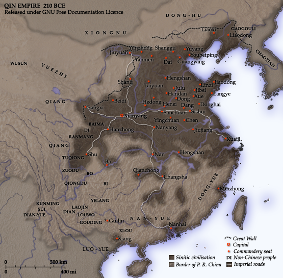
English: Map of the Qin Dynasty (in c. 210 BCE) — in China. ::*The first unifying Imperial dynasty of China. ::*The coloured territories show the approximate extent of Qin political control at the death of Emperor Qin Shi Huang in 210 BC.
As part of his unification of China in 221 BCE, Qin Shi Huang divided his empire into thirty six commanderies, each subdivided into a number of counties. The significance of the administrative reforms was its introduction of a uniformly centralised system of imperial control. At the death of Qin Shi Huang in 210 BCE, more commanderies were added to the original thirty six, and these are also shown on the map.
  • The system was followed by the Han Dynasty (206 BCE – 220 CE), though with a certain degree of compromise. Thereafter, the system became the norm for later dynasties and eventually evolved into the present administrative structure of Mainland China (see: Category: Political divisions of China.) The location of the Yellow River and commandery seats follows Tan Qixiang (ed.), Zhongguo lishi ditu (中国历史地图集), 1982. Note that the Yellow River is considerably to the north of its present flow. ;Credits Created and copyright (2006) by Yeu Ninje. Released under the GNU FDL. Originally uploaded to English Wikipedia by en:User:Yeu Ninje.
  • Han civilisation
    Han civilisation
Огноо 1982. (2006).
Эх үүсвэр Self-published work by Itsmine
Зохиогч Itsmine
This historical map image could be re-created using vector graphics as an SVG file. This has several advantages; see Commons:Media for cleanup for more information. If an SVG form of this image is available, please upload it and afterwards replace this template with {{vector version available|new image name}}.


It is recommended to name the SVG file “Qin empire 210 BCE.svg”—then the template Vector version available (or Vva) does not need the new image name parameter.

Лиценз

I, the copyright holder of this work, hereby publish it under the following licenses:
GNU head Энэхүү баримт бичгийг GNU Free Documentation License, Хувилбарын нөхцлийн дагуу хуулах, түгээх болон/эсвэл өөрчлөх зөвшөөрөл олгосон. 1.2 эсвэл Чөлөөт програм хангамжийн сангаас нийтэлсэн дараагийн хувилбар; Инвариант хэсэггүй, нүүрэн талын текстгүй, арын хавтастай текстгүй. Лицензийн хуулбарыг GNU Free Documentation License гэсэн хэсэгт оруулсан болно.
w:en:Creative Commons
хамаарал адилхан хуваалцах
Энэ файл нь Creative Commons Attribution-Share Alike 3.0 Unported лицензтэй байна.
Та чөлөөтэй:
  • хуваалцах – бүтээлийг хуулбарлах, түгээх, дамжуулах
  • ремикс хийх – ажлыг тохируулах
Дараах нөхцөлд:
  • хамаарал – Та зохих кредитийг өгч, лицензийн холбоосыг өгч, өөрчлөлт оруулсан эсэхийг зааж өгөх ёстой. Та үүнийг ямар ч боломжийн аргаар хийж болно, гэхдээ лиценз олгогч таныг эсвэл таны хэрэглээг зөвшөөрөхгүй.
  • адилхан хуваалцах – Хэрэв та материалыг дахин найруулах, хувиргах эсвэл бүтээх юм бол same or compatible license-ийн дагуу өөрийн хувь нэмрийг эх хувьтай нь түгээх ёстой.
This licensing tag was added to this file as part of the GFDL licensing update.
Та өөрийн хүссэн лицензээ сонгож болно.

Captions

Add a one-line explanation of what this file represents
A map of the Qin Dynasty circa 210 BCE.

Items portrayed in this file

depicts англи

creator англи

copyright status англи

copyrighted англи

Файлын түүх

Огноо/цаг дээр дарж тухайн үеийнх нь файлын байдлыг харна уу.

Огноо/ЦагЖижиг зурагХэмжээХэрэглэгчТайлбар
одоогийн14:37, 10 Арванхоёрдугаар сар 201414:37, 10 Арванхоёрдугаар сар 2014-н байдлаарх хувилбарын жижиг хувилбар555 × 545 (567 КБ)Nguyen1310Update to include ''Luo-Yue'' (Vi: ''Lạc Việt'') a member of the Baiyue (100 Yue) peoples, on the map in northern Vietnam.
14:08, 21 Арваннэгдүгээр сар 200614:08, 21 Арваннэгдүгээр сар 2006-н байдлаарх хувилбарын жижиг хувилбар555 × 545 (540 КБ)Itsmine== Commentary == As part of his unification of China in 221 BC, Qin Shi Huang divided his empire into thirty six commanderies, each subdivided into a number of counties. The significance of the administrative reforms was its in

Энэ файлд холбоос хийсэн хуудас байхгүй байна.

Файлын хэрэглээ (бүх төсөл)

Дараах бусад вики энэ файлыг ашигладаг:

Энэ файлын дэлхийн хэрэглээг харах.