Файл:ROC PRC comparison eng.jpg

Page contents not supported in other languages.

ROC_PRC_comparison_eng.jpg(770 × 600 пиксел, файлын хэмжээ: 239 КБ, MIME төрөл: image/jpeg)

Энэ файл нь Wikimedia Commons-нх бөгөөд бусад төслүүд үүнийг хэрэглэх боломжтой. Доор файлын тайлбарын хуудсан дээрх тайлбарыг оруулсан байгаа:

File:ROC vs PRC.svg is a vector version of this file. It should be used in place of this JPG file when not inferior.

File:ROC PRC comparison eng.jpg → File:ROC vs PRC.svg

For more information, see Help:SVG.

In other languages
Alemannisch  Bahasa Indonesia  Bahasa Melayu  British English  català  čeština  dansk  Deutsch  eesti  English  español  Esperanto  euskara  français  Frysk  galego  hrvatski  Ido  italiano  lietuvių  magyar  Nederlands  norsk bokmål  norsk nynorsk  occitan  Plattdüütsch  polski  português  português do Brasil  română  Scots  sicilianu  slovenčina  slovenščina  suomi  svenska  Tiếng Việt  Türkçe  vèneto  Ελληνικά  беларуская (тарашкевіца)  български  македонски  нохчийн  русский  српски / srpski  татарча/tatarça  українська  ქართული  հայերեն  বাংলা  தமிழ்  മലയാളം  ไทย  한국어  日本語  简体中文  繁體中文  עברית  العربية  فارسی  +/−
New SVG image

Atlas This map has been uploaded by Electionworld from en.wikipedia.org to enable the Wikimedia Atlas of the World . Original uploader to en.wikipedia.org was Pryaltonian, known as Pryaltonian at en.wikipedia.org. Electionworld is not the creator of this map. Licensing information is below.

Товч агуулга

Тайлбар
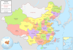
English: Comparison between Republic of China and People's Republic of China administrative divisions.
Legend details
  • Black dotted lines are political boundaries drawn by the ROC. The formal names of these political entities are in black
  • White areas represent the territories claimed by the ROC but not the PRC.
  • The names and the boundary of "South China Sea" is self-claimed by China, which has no valid supported document. Therefore, It is remain a false information and should not be visible anywhere to prevent miseducation.
Origin

Adapted into English by Pryaltonian from the Chinese Wikipedia. The original ROC map included more cities, but the adaptation removed non-central municipalities to clean up the image. Therefore, this image contains:

Republic of China

  • 35 provinces
  • 14 municipalities
  • 2 areas
  • 1 special administrative region

People's Republic of China

  • 23 provinces
  • 4 municipalities
  • 5 autonomous regions
  • 2 special administrative regions

The image also includes the addition of Chongqing as a municipality and the Gansu-Qinghai border change.

Comments, suggestions, adaptations, critiques are all welcome.
Огноо
Эх үүсвэр Энэ миний бүтээл
Зохиогч Electionworld

Лиценз

GNU head Энэхүү баримт бичгийг GNU Free Documentation License, Хувилбарын нөхцлийн дагуу хуулах, түгээх болон/эсвэл өөрчлөх зөвшөөрөл олгосон. 1.2 эсвэл Чөлөөт програм хангамжийн сангаас нийтэлсэн дараагийн хувилбар; Инвариант хэсэггүй, нүүрэн талын текстгүй, арын хавтастай текстгүй. Лицензийн хуулбарыг GNU Free Documentation License гэсэн хэсэгт оруулсан болно.
w:en:Creative Commons
хамаарал адилхан хуваалцах
Энэ файл нь Creative Commons Attribution-Share Alike 3.0 Unported лицензтэй байна.
Та чөлөөтэй:
  • хуваалцах – бүтээлийг хуулбарлах, түгээх, дамжуулах
  • ремикс хийх – ажлыг тохируулах
Дараах нөхцөлд:
  • хамаарал – Та зохих кредитийг өгч, лицензийн холбоосыг өгч, өөрчлөлт оруулсан эсэхийг зааж өгөх ёстой. Та үүнийг ямар ч боломжийн аргаар хийж болно, гэхдээ лиценз олгогч таныг эсвэл таны хэрэглээг зөвшөөрөхгүй.
  • адилхан хуваалцах – Хэрэв та материалыг дахин найруулах, хувиргах эсвэл бүтээх юм бол same or compatible license-ийн дагуу өөрийн хувь нэмрийг эх хувьтай нь түгээх ёстой.
This licensing tag was added to this file as part of the GFDL licensing update.

GNU was used on the Chinese page, so same copyright information should apply. -Pryaltonian 04:45, 3 September 2006 (UTC)

Captions

Add a one-line explanation of what this file represents

Items portrayed in this file

depicts англи

creator англи

copyright status англи

copyrighted англи

3 Долоодугаар сар 2006

MIME type англи

image/jpeg

Файлын түүх

Огноо/цаг дээр дарж тухайн үеийнх нь файлын байдлыг харна уу.

Огноо/ЦагЖижиг зурагХэмжээХэрэглэгчТайлбар
одоогийн19:48, 18 Нэгдүгээр сар 201519:48, 18 Нэгдүгээр сар 2015-н байдлаарх хувилбарын жижиг хувилбар770 × 600 (239 КБ)WwbreadPart of Bhutan and Russia was Rep. China. It has been marked in this map but not painted white. Also marked Nanking and Peking by two bigger stars.
14:03, 16 Арванхоёрдугаар сар 200614:03, 16 Арванхоёрдугаар сар 2006-н байдлаарх хувилбарын жижиг хувилбар770 × 600 (316 КБ)Electionworld{{ew|en|Pryaltonian}} == Legend details == * Black dotted lines are political boundaries drawn by the ROC. The formal names of these political entities are in black text. * Red solid lines are political boundaries drawn by the [[P

Энэ файлд холбоос хийсэн хуудас байхгүй байна.

Файлын хэрэглээ (бүх төсөл)

Дараах бусад вики энэ файлыг ашигладаг:

Энэ файлын дэлхийн хэрэглээг харах.