Файл:Arab population israel 2000 en.png
Page contents not supported in other languages.

Эх файл(692 × 1,575 пиксел, файлын хэмжээ: 182 КБ, MIME төрөл: image/png)

Энэ файл нь Wikimedia Commons-нх бөгөөд бусад төслүүд үүнийг хэрэглэх боломжтой. Доор файлын тайлбарын хуудсан дээрх тайлбарыг оруулсан байгаа:

Товч агуулга

Тайлбар
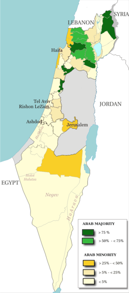
English: Map of the officials 50 "natural regions" of Israel, with their proportions of arab population. The map includ the Golan heights and east Jerusalem, two areas annexed by Israel, annexions not recognize by UNO. The map is based on the demographic situation 2000, and is based upon the arab population in Israel [PDF], a publication (Statistilite N°27) of the israeli Center Bureau of Statistics (CBS) diffused in november 2002.
Français : Carte des 50 "régions naturelles" officiellement reconnues par l'état, subdivision des 15 sous-districts, avec la proportion de population arabe. Cette carte inclue Jérusalem-Est et le plateau du Golan, tous deux annexés par Israël, mais dont l'annexion n'est pas reconnue par l'ONU. La carte est basée sur la situation de la population en l'an 2000, et est inspirée de the arab population in Israel [PDF], une publication (Statistilite N°27) du Center Bureau of Statistics israélien (CBS) diffusée en novembre 2002.
Огноо
Эх үүсвэр Own work, derivative work of: File:Israel population density.png
Зохиогч Christophe cagé
Other versions File:Arabe population israel 2000 fr.png

Лиценз

© The copyright holder of this file, Israel Central Bureau of Statistics, allows anyone to use it for any purpose, provided that the copyright holder is properly attributed. Redistribution, derivative work, commercial use, and all other use is permitted.
Атрибут:
The Central Bureau of Statistics (CBS), {{{filename}}}, ({{{access-date}}}), [{{{link}}} available online] copied and distributed as is in accordance with the CBS license.

{{{template}}} According to the CBS license, you may not make the following use of the Information, whether by positive act or by omission:
  • present the Information in a misleading manner;
  • present the Information in a way that suggests that the Central Bureau of Statistics, or the State of Israel, supports or endorses you or your use of the Information;
  • make use of the Information in a manner that breaches any applicable law;
  • make use of the Information in a manner that infringes a person's privacy, including merging the Information with other sources of information with the intent of attempting to identify any individual person, business or organization;
  • present the Information in such a manner that gives the appearance that you may have received, or had access to, information held by the Office about any identifiable individual person, business or organization.
I, the copyright holder of this work, hereby publish it under the following licenses:
GNU head Энэхүү баримт бичгийг GNU Free Documentation License, Хувилбарын нөхцлийн дагуу хуулах, түгээх болон/эсвэл өөрчлөх зөвшөөрөл олгосон. 1.2 эсвэл Чөлөөт програм хангамжийн сангаас нийтэлсэн дараагийн хувилбар; Инвариант хэсэггүй, нүүрэн талын текстгүй, арын хавтастай текстгүй. Лицензийн хуулбарыг GNU Free Documentation License гэсэн хэсэгт оруулсан болно.
w:en:Creative Commons
хамаарал адилхан хуваалцах
This file is licensed under the Creative Commons Attribution-Share Alike 3.0 Unported, 2.5 Generic, 2.0 Generic and 1.0 Generic license.
Та чөлөөтэй:
  • хуваалцах – бүтээлийг хуулбарлах, түгээх, дамжуулах
  • ремикс хийх – ажлыг тохируулах
Дараах нөхцөлд:
  • хамаарал – Та зохих кредитийг өгч, лицензийн холбоосыг өгч, өөрчлөлт оруулсан эсэхийг зааж өгөх ёстой. Та үүнийг ямар ч боломжийн аргаар хийж болно, гэхдээ лиценз олгогч таныг эсвэл таны хэрэглээг зөвшөөрөхгүй.
  • адилхан хуваалцах – Хэрэв та материалыг дахин найруулах, хувиргах эсвэл бүтээх юм бол same or compatible license-ийн дагуу өөрийн хувь нэмрийг эх хувьтай нь түгээх ёстой.
Та өөрийн хүссэн лицензээ сонгож болно.

Captions

Add a one-line explanation of what this file represents

Items portrayed in this file

depicts англи

creator англи

copyright status англи

copyrighted англи

22 Хоёрдугаар сар 2009

media type англи

image/png

checksum англи

5afc0b91dfe8d983a85af862f3a58ec981a8a743

determination method англи: SHA-1 англи

data size англи

186,138 byte

height англи

1,575 pixel

width англи

692 pixel

Файлын түүх

Огноо/цаг дээр дарж тухайн үеийнх нь файлын байдлыг харна уу.

Огноо/ЦагЖижиг зурагХэмжээХэрэглэгчТайлбар
одоогийн13:48, 15 Долоодугаар сар 201413:48, 15 Долоодугаар сар 2014-н байдлаарх хувилбарын жижиг хувилбар692 × 1,575 (182 КБ)Hruska~commonswikiReverted to version as of 08:23, 22 February 2009
13:47, 15 Долоодугаар сар 201413:47, 15 Долоодугаар сар 2014-н байдлаарх хувилбарын жижиг хувилбар692 × 1,575 (182 КБ)Hruska~commonswikiReverted to version as of 08:23, 22 February 2009 Revert Edit, The Golan and East Jerusalem de facto Israel, Syria giving Status qo
13:46, 15 Долоодугаар сар 201413:46, 15 Долоодугаар сар 2014-н байдлаарх хувилбарын жижиг хувилбар692 × 1,575 (182 КБ)Hruska~commonswikiReverted to version as of 08:23, 22 February 2009
15:38, 21 Дөрөвдүгээр сар 200915:38, 21 Дөрөвдүгээр сар 2009-н байдлаарх хувилбарын жижиг хувилбар692 × 1,575 (165 КБ)MeteorMaker~commonswiki{{Information |Description={{en|1=Map of the officials 50 "natural regions" of Israel, with their proportions of arab population. The map includ the Golan heights and east Jerusalem, two areas annexed by Israel, annexions not recognize by UNO. The map is
08:23, 22 Хоёрдугаар сар 200908:23, 22 Хоёрдугаар сар 2009-н байдлаарх хувилбарын жижиг хувилбар692 × 1,575 (182 КБ)Christophe cagé{{Information |Description={{en|1=x}} {{fr|1=x}} |Source=travail personnel (own work) |Author=Christophe cagé |Date=22 february 2009 |Permission=SEE LICENSE |other_versions= }} <!--{{ImageUpload|full}}-->

Дараахь хуудсууд уг файлтай холбогдсон байна:

Файлын хэрэглээ (бүх төсөл)

Дараах бусад вики энэ файлыг ашигладаг:

Зургийн тухай мэдээлэл