Файл:Bohaiseamap2.png

Page contents not supported in other languages.

Bohaiseamap2.png(569 × 487 пиксел, файлын хэмжээ: 136 КБ, MIME төрөл: image/png)

Энэ файл нь Wikimedia Commons-нх бөгөөд бусад төслүүд үүнийг хэрэглэх боломжтой. Доор файлын тайлбарын хуудсан дээрх тайлбарыг оруулсан байгаа:

Warning sign This file requires updating because: I suggest using the more normative 'Pyongyang' and 'Yellow River' or at least adding these forms in parentheses. In doing so, you could add a timestamp to the file.
Please notify the uploader with {{subst:update-note|1=File:Bohaiseamap2.png|2=I suggest using the more normative 'Pyongyang' and 'Yellow River' or at least adding these forms in parentheses.}} ~~~~

Товч агуулга

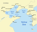
Тайлбар Map of the Bohai Sea and surrounding bays. For a more general map of the same area see Image:Bohai Sea map.png
Огноо
Эх үүсвэр self-made, based on DCW data.
Зохиогч Kmusser
Other versions

Derivative works of this file:

This map image could be re-created using vector graphics as an SVG file. This has several advantages; see Commons:Media for cleanup for more information. If an SVG form of this image is available, please upload it and afterwards replace this template with {{vector version available|new image name}}.


It is recommended to name the SVG file “Bohaiseamap2.svg”—then the template Vector version available (or Vva) does not need the new image name parameter.

Лиценз

I, the copyright holder of this work, hereby publish it under the following license:
w:en:Creative Commons
хамаарал адилхан хуваалцах
This file is licensed under the Creative Commons Attribution-Share Alike 2.5 Generic license.
Та чөлөөтэй:
  • хуваалцах – бүтээлийг хуулбарлах, түгээх, дамжуулах
  • ремикс хийх – ажлыг тохируулах
Дараах нөхцөлд:
  • хамаарал – Та зохих кредитийг өгч, лицензийн холбоосыг өгч, өөрчлөлт оруулсан эсэхийг зааж өгөх ёстой. Та үүнийг ямар ч боломжийн аргаар хийж болно, гэхдээ лиценз олгогч таныг эсвэл таны хэрэглээг зөвшөөрөхгүй.
  • адилхан хуваалцах – Хэрэв та материалыг дахин найруулах, хувиргах эсвэл бүтээх юм бол same or compatible license-ийн дагуу өөрийн хувь нэмрийг эх хувьтай нь түгээх ёстой.

Captions

Add a one-line explanation of what this file represents
Map of the Bohai Sea and surrounding bays

Items portrayed in this file

depicts англи

creator англи

copyright status англи

copyrighted англи

27 Зургаадугаар сар 2007

media type англи

image/png

checksum англи

e776fb894d1db142a63c8f0d600c8d6c18de759c

determination method англи: SHA-1 англи

data size англи

139,100 byte

height англи

487 pixel

width англи

569 pixel

Файлын түүх

Огноо/цаг дээр дарж тухайн үеийнх нь файлын байдлыг харна уу.

Огноо/ЦагЖижиг зурагХэмжээХэрэглэгчТайлбар
одоогийн19:33, 7 Нэгдүгээр сар 202119:33, 7 Нэгдүгээр сар 2021-н байдлаарх хувилбарын жижиг хувилбар569 × 487 (136 КБ)Ras67black frame cropped and alpha channel removed
14:59, 27 Зургаадугаар сар 200714:59, 27 Зургаадугаар сар 2007-н байдлаарх хувилбарын жижиг хувилбар583 × 500 (179 КБ)Kmusseradded strait
14:50, 27 Зургаадугаар сар 200714:50, 27 Зургаадугаар сар 2007-н байдлаарх хувилбарын жижиг хувилбар500 × 429 (141 КБ)Kmusser{{Information |Description=Map of the Bohai Sea and surrounding bays. For a more general map of the same area see Image:Bohai Sea map.png |Source=self-made, based on DCW data. |Date=June 27, 2007

Дараахь хуудсууд уг файлтай холбогдсон байна:

Файлын хэрэглээ (бүх төсөл)

Дараах бусад вики энэ файлыг ашигладаг:

Энэ файлын дэлхийн хэрэглээг харах.

Зургийн тухай мэдээлэл