
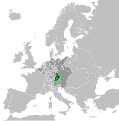
Файл:Electorate of Bavaria 1789.svg

Size of this PNG preview of this SVG file: 450 × 456 пиксел. Бусад зургын нягтрал: 237 × 240 пиксел | 474 × 480 пиксел | 758 × 768 пиксел | 1,011 × 1,024 пиксел | 2,021 × 2,048 пиксел.
Эх файл (SVG файл, 450 × 456 пиксэл, файлын хэмжээ: 928 КБ)
Товч агуулга


.svg)
.svg)
.svg)
.svg)
.svg)


.svg)
.svg)
.svg)


.png)
.png)


.svg)


.svg)

.svg)


.svg)
.svg)
.svg)
.svg)


.svg)
.png)


.svg)


.svg)
.svg)


.svg)


.svg)


.svg)
.svg)
.svg)
.svg)
.svg)
.svg)
.svg)
_cropped.svg)
.svg)
.svg)
.svg)
.svg)
.svg)
.svg)
.svg)
.svg)
.svg)
.svg)
.svg)
.svg)
.svg)
.svg)
.svg)
.svg)
.svg)
.svg)
.svg)
.svg)
.svg)
.svg)
.svg)
.svg)
.svg)
.svg)
.svg)
.svg)
.svg)
.svg)
.svg)
.svg)
.svg)
.svg)
.svg)
.svg)
.svg)
.svg)
.svg)
.svg)
.svg)
.svg)
.svg)
.svg)
.svg)
Лиценз
I, the copyright holder of this work, hereby publish it under the following license:
Энэ файл нь Creative Commons Attribution-Share Alike 3.0 Unported лицензтэй байна.
- Та чөлөөтэй:
- хуваалцах – бүтээлийг хуулбарлах, түгээх, дамжуулах
- ремикс хийх – ажлыг тохируулах
- Дараах нөхцөлд:
- хамаарал – Та зохих кредитийг өгч, лицензийн холбоосыг өгч, өөрчлөлт оруулсан эсэхийг зааж өгөх ёстой. Та үүнийг ямар ч боломжийн аргаар хийж болно, гэхдээ лиценз олгогч таныг эсвэл таны хэрэглээг зөвшөөрөхгүй.
- адилхан хуваалцах – Хэрэв та материалыг дахин найруулах, хувиргах эсвэл бүтээх юм бол same or compatible license-ийн дагуу өөрийн хувь нэмрийг эх хувьтай нь түгээх ёстой.
Original upload log
This image is a derivative work of the following images:
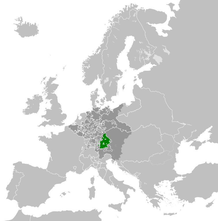
- File:Europe_1789.svg licensed with Cc-by-sa-3.0
- 2013-04-14T03:44:26Z Alphathon 450x456 (858577 Bytes) Corrected some errors in northern Italy
- 2013-04-14T01:38:01Z Alphathon 450x456 (853881 Bytes) tweaked again
- 2013-04-14T01:36:10Z Alphathon 450x456 (853881 Bytes) Tweaked Holy Roman Empire border style
- 2013-04-14T01:33:26Z Alphathon 450x456 (853857 Bytes) == {{int:filedesc}} == {{Information |Description={{en|A blank Map of Europe circa 1789. This map also includes a border for the [[:en:Holy Roman Empire|Holy Roman Empire]]. Since there are so many small German states, they h
Uploaded with derivativeFX
Файлын түүх
Огноо/цаг дээр дарж тухайн үеийнх нь файлын байдлыг харна уу.
| Огноо/Цаг | Жижиг зураг | Хэмжээ | Хэрэглэгч | Тайлбар | |
|---|---|---|---|---|---|
| одоогийн | 07:48, 17 Аравдугаар сар 2021 | | 450 × 456 (928 КБ) | Fenn-O-maniC | Fixed the Russo-Swedish border to match the Treaty of Åbo of 1743 |
| 19:26, 18 Дөрөвдүгээр сар 2013 |  | 450 × 456 (948 КБ) | Alphathon | Various fixes and style change | |
| 14:41, 18 Дөрөвдүгээр сар 2013 |  | 450 × 456 (849 КБ) | Alphathon | Fixed Scandinavian borders | |
| 16:00, 14 Дөрөвдүгээр сар 2013 |  | 450 × 456 (834 КБ) | Alphathon | == {{int:filedesc}} == {{Information |Description={{en|A map of the Electorate of Bavaria circa 1789.}}{{de|Eine Landkarte das Kurfürstentum Bayern c. 1789.}} |Source={{Derived from|Europe_17... |
Холбоос
Энэ файлд холбоос хийсэн хуудас байхгүй байна.
Файлын хэрэглээ (бүх төсөл)
Дараах бусад вики энэ файлыг ашигладаг:
- bg.wikipedia.org дахь хэрэглээ
- hu.wikipedia.org дахь хэрэглээ
- ko.wikipedia.org дахь хэрэглээ
- lt.wikipedia.org дахь хэрэглээ
- ru.wikipedia.org дахь хэрэглээ