
Файл:Polska 1333 - 1370 (it).png
Үзлэгийн хэмжээ : 630 × 599 пиксел Бусад зургын нягтрал: 252 × 240 пиксел | 505 × 480 пиксел | 808 × 768 пиксел | 1,077 × 1,024 пиксел | 2,153 × 2,048 пиксел | 2,636 × 2,507 пиксел.
Эх файл (2,636 × 2,507 пиксел, файлын хэмжээ: 1.99 МБ, MIME төрөл: image/png)
.png)
Товч агуулга
| Тайлбар |
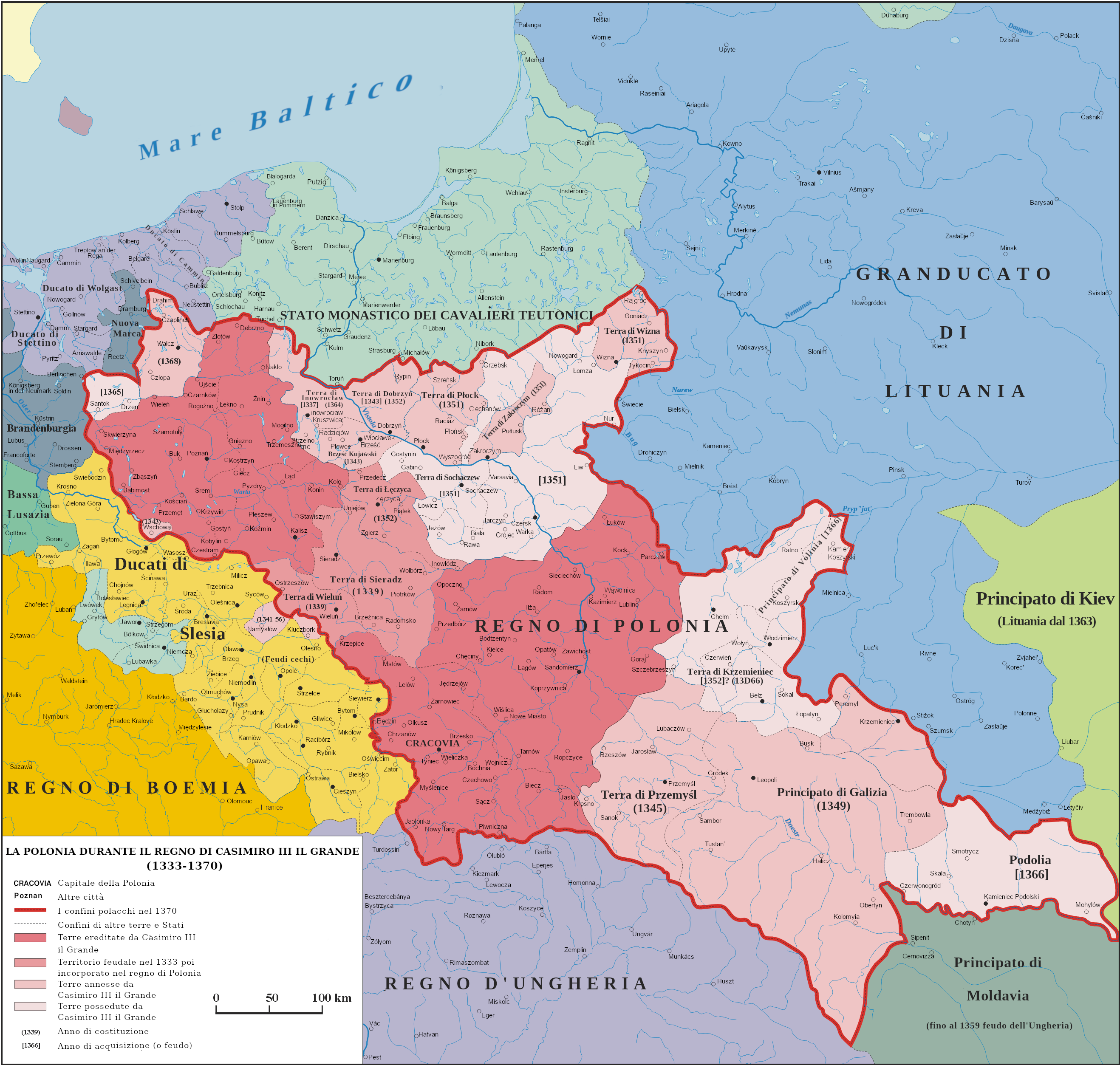
English: Map of Poland and territorial borders during the reign of Casimir III the Great (1333 - 1370)
Italiano: Mappa della Polonia e dei territori di confine durante il regno di Casimiro III il Grande (1333 - 1370) |
| Огноо | |
| Эх үүсвэр | Энэ миний бүтээл na podstawie "Ilustrowany atlas historii Polski, wyd. Demart, Warszawa 2006" |
| Зохиогч | Poznaniak (traslate by Adert) |
| Зөвшөөрөл (Энэ файлыг дахин ашиглах) |
I, the copyright holder of this work, hereby publish it under the following license: Энэ файл нь Creative Commons Attribution-Share Alike 3.0 Unported лицензтэй байна.
|
| Other versions |
 |
Лиценз
I, the copyright holder of this work, hereby publish it under the following license:
Энэ файл нь Creative Commons Attribution-Share Alike 3.0 Unported лицензтэй байна.
- Та чөлөөтэй:
- хуваалцах – бүтээлийг хуулбарлах, түгээх, дамжуулах
- ремикс хийх – ажлыг тохируулах
- Дараах нөхцөлд:
- хамаарал – Та зохих кредитийг өгч, лицензийн холбоосыг өгч, өөрчлөлт оруулсан эсэхийг зааж өгөх ёстой. Та үүнийг ямар ч боломжийн аргаар хийж болно, гэхдээ лиценз олгогч таныг эсвэл таны хэрэглээг зөвшөөрөхгүй.
- адилхан хуваалцах – Хэрэв та материалыг дахин найруулах, хувиргах эсвэл бүтээх юм бол same or compatible license-ийн дагуу өөрийн хувь нэмрийг эх хувьтай нь түгээх ёстой.

|
This historical map image could be re-created using vector graphics as an SVG file. This has several advantages; see Commons:Media for cleanup for more information. If an SVG form of this image is available, please upload it and afterwards replace this template with
{{vector version available|new image name}}.
It is recommended to name the SVG file “Polska 1333 - 1370 (it).svg”—then the template Vector version available (or Vva) does not need the new image name parameter. |
Файлын түүх
Огноо/цаг дээр дарж тухайн үеийнх нь файлын байдлыг харна уу.
| Огноо/Цаг | Жижиг зураг | Хэмжээ | Хэрэглэгч | Тайлбар | |
|---|---|---|---|---|---|
| одоогийн | 09:23, 26 Нэгдүгээр сар 2024 | | 2,636 × 2,507 (1.99 МБ) | Adert | Fix error |
| 08:59, 4 Арваннэгдүгээр сар 2023 |  | 2,636 × 2,507 (1.99 МБ) | Adert | Uploaded own work with UploadWizard |
Холбоос
Дараахь хуудсууд уг файлтай холбогдсон байна:
Файлын хэрэглээ (бүх төсөл)
Дараах бусад вики энэ файлыг ашигладаг:
- fr.wikipedia.org дахь хэрэглээ
- it.wikipedia.org дахь хэрэглээ
- pt.wikipedia.org дахь хэрэглээ
.png)